Donna and Bill Grimes invited the HCC club to join
them on a portion of their three-month vacation. Twenty people accepted
eight from Houston, three from Spring Branch (Hill Country), one from
Pennsylvania, four from North Carolina, two from Georgia, one from Utah,
and one from Colorado. One of the Houstonians had to return to Texas
because of a family crisis and our hearts went out to him.
It was a very loose trip; Donna started us off with suggestions of
rivers in each of the three areas we stayed. At night, we talked about
the next day’s run and settled our plans. Some days everyone paddled and
other days the group split up to paddle and hike.
This is a short summary of my trip. I used the river guide "Western
Whitewater: From the Rockies to the Pacific", by Jim Cassady, Bill
Cross, and Fryar Calhoun, for the technical details.
Friday, July 9
Headed out from Pearland, TX around 9:30 pm and arrived in Vernon,
Texas around 7:00pm.
Saturday, July 10
Left Vernon around 8:00am and arrived in Santa Fe, New Mexico,
around 3:30. Steve and I had dinner with Donna and Bill Grimes and
Marilyn and Cliff Peery in the center of town at a little restaurant
that Bill and Donna frequented fifteen years ago.
Afterward we all drove to the Motel 6 in Espanola, New Mexico. From
the motel Donna, Bill and I drove to the Chavez Canyon put in on the Rio
Chama, just to check out the drive. Steve stayed at the motel, not
interested in the one-hundred mile round trip “just to check it out.” We
met Ken Anderson, Dick and a few others that camped in the BML
campground. I included a website for Bureau of Land Management (BLM)
campgrounds and information about the Rio Chama and Rio Grande rivers: http://www.blm.gov/nm/st/en.html
When we returned to Motel 6, we found Kathy, Tom, and Julie
socializing with Steve at the Sonic. The group was getting bigger. After
greeting each other, we settled in the parking lot; sitting in our camp
chairs, drinking, discussing the events of the day, and the upcoming
river adventures.
Sunday, July 11
Wild and Scenic Rio Chama, New Mexico
Chavez Canyon Access to Big Eddy
8.7 miles
800 CFS, USGS 08285500 and USGS 08286500
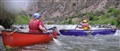
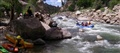
The day was warm, hot, sunny, no breeze. The water was cold
(Guadalupe river below the dam cold). There were about seventeen of us
on the water that day. The landscape was picture perfect with blue
skies, billowy white clouds, and beautiful mountains in the background.
The Chama is on the wide side, fast moving but not a lot of gradient (15
ft/mi.) and made for a great warm up river.
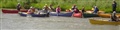
|
| Rio Chama Put-in |
|
| Cliff on the Chama |
|
| Donna Paddling the Chama |
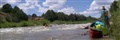
|
| Dick on the Chama, Bill as Safety |
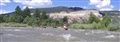
|
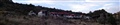
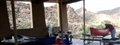
| Parking at the Orilla Verde Recreational Area (BLM
Taos) |
|
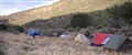
| Campsite down the slope from the shelter |
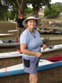
Donna
rented the shelter and the camping area (right). This recreation area
had running water, electricity, and bathrooms. It was very clean and we
had a wonderful view of mountains. Steve and I went swimming in the Rio
Grande River that ran close to the camp. On the first day this canyon
was so windy that we thought the tents were going to fly away.
Monday, July 12
Wild and Scenic Rio Grande, New Mexico
Race Course Run, Quartzite Recreation Site to Taos Country Line
Recreation Site
4.3 miles; gradient 34 ft./mi.
260 CFS, USGS 08276500
The day was warm, sunny, with no breeze, but we worn combinations of
paddling jackets, long pants, wet suits and neoprene because the water
is cold. This run was conveniently located a few miles from camp. We
took our time on the river stopping to play as much as possible and eddy
hopping constantly.
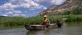
|
| Bill Making his way down the Rio Grande |
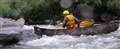
|
| Cliff Surfing on the Race Course |
|
| Donna Surfing and Dorothy waiting to Surf |
|
| Canoe Mash Unit (1) |
Jim
(not pictured) pulled a thigh strap loose and with the help from Kathy
(not pictured) fixed it in no time at all. He paddled the boat for the
rest of the week with no problems. (Photo by Ken Anderson)
|
| Canoe Mash Unit (2) |
Dorothy
broke her thwart. She and Dave went to the hardware store and purchased
a piece of lumber the correct height and width. The store cut it to the
correct length and drilled holes. Dave installed the thwart, and the
boat was as good as new. (Photo by Ken Anderson)
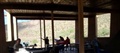
|
| View from the open side of the Canoe Mash Unit of the
Shelter |
The shelter also served as our
dining area, a gathering area for socializing, and for some a sleeping
area. (Photo by Ken Anderson)
Tuesday, July 13
Wild and Scenic Rio Grande, New Mexico
Race Course Run, Quartzite Recreation Site to Taos Country Line
Recreation Site
4.3 miles; gradient 34 ft./mi.
260 CFS, USGS 08276500
This was another beautiful day with perfect weather. Since this was a
moving day with a 150-mile drive to the next campsite, we decided to
run the Race Course again. At Screaming Left rapid, one of our
sit-on-top paddlers lost his double-bladed paddle. I loaned him my
paddle and I used a single blade for the rest of the trip. I was very
happy to be somewhat familiar with the run. We had a blast once again.
The drive to the Buena Vista KOA campground was pleasant and Steve
and I drove HWY 285 through wide-open plains with the mountain ranges in
the background. There was rain in the distance but it never affected
us.
The KOA campground store had the biggest marshmallows I have ever
seen. I bought a bag for the grandkids. This was a well-maintained place
with friendly workers, and beautiful scenery. I used the showers, ate
breakfast at the cook shack, and played horseshoes. I recommend it for
long stays or bigger groups.
www.buenavistakoa.com
Donna arranged with a local boater, Larry Rice, to meet us at the
campground and discuss Wednesdays paddle. I knew Larry from the many
articles he authored in ACA Paddler Magazine and Canoe and Kayak
Magazine. He was very open and frank about what to expect from the
different runs on the Arkansas at the current level. We decided on
Browns Canyon from Fisherman’s Bridge to Hecla Campground.
Wednesday, July 14
Arkansas River, Browns Canyon, Colorado
Fisherman’s Bridge to Hecla Campground
9 miles; gradient 27 ft./mi.
600 CFS, USGS 07091200
www.allaboutrivers.com/rivers-in-colorado/browns-canyon-RUN25.html
Good paddling weather sunny and hot. The put in included a very long
portage to the river. Fortunately, it had a double rail to rest the
boats on and walk them down to the river.
This portion of the Arkansas has rapids with attention getting names
like Zoom-Flume, Toilet Bowl, Raft Ripper, and Widow Maker. The run
started out fast with a lot of busy water and rocks that nudged and
grabbed your boat.
Larry suggested we dress for cold water and cold weather. He was on
the money because as the hot day wore on and there were more clouds and
less sun, it became cold. It was great run with fast current pushing you
into big rocks. Zume-Flume was the longest and biggest in my opinion. I
paddled it left of center and had a great time skirting or punching
through holes, maneuvering around boulders, and riding wave trains.
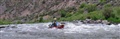
|
| Billy Guiding a Raft down Zoom-Flume on the Arkansas |
Billy
guided a rafted down the run, giving people another way to experience
the river.
Thursday, July 15, 2010
Arkansas River, New Mexico
Numbers 6 and 7 to Railroad Bridge Recreation Site
3 miles; gradient 65 ft./mi.
600 CFS, USGS 07091200
Larry Rice was on this trip also. He took us down rapids 6 and 7 as a
warm up for the Fractions. I was constantly recovering and had a hard
time reading the fast water. When we came to the Railroad Bridge
Recreation Site several of us decided to try a different run. Therefore,
the group split up and four continued to Buena Vista River Park.
Arkansas River, New Mexico
Buena Vista River Park to Fisherman’s Bridge
2 miles; gradient 50 ft./mi. –4.4 miles; gradient 30 ft./mi.
600 CFS, USGS 07091200
My group decided to put in at Buena Vista River Park and take out at
Fisherman’s Bridge. What a wild ride, the rapids were challenging but
there was more busy water between the rapids. At mile 20.3 close to the
Johnson Village Bridge, the Milk Run begins. I would not recommend the
Milk Run if you only have a few days to paddle whitewater. Compared to
the other sections of the Arkansas, it is four and a-half miles of slow
water.
Friday, July 16
We said our goodbyes, Friday morning, as the group headed out for
another day on the river. Steve and I packed up and headed south on HWY
285 until we hit Fort Stockton, TX.
Saturday, July 17
We rolled into our driveway before sunset. We were tired from all
the driving and crashed on the couch. We put 2700 miles on the car and I
put 35.7 miles on my kayak.
I want to thank Donna for coordinating a great trip. The camping was
great, the rivers challenging, and the local paddlers interesting.
Christy Long
|