The Devil’s River has long been on my bucket list of places to paddle and I was pleased the opportunity presented itself in a private trip facilitated by HASK paddler Paul Penning. Our group of six paddlers was scouting this with an eye to running more official trips later. Let me add a few spoiler alerts here: the unanimous conclusion of all six of us was that once was enough. The physical exertion required to paddle the 30 miles of river was so intense, none of us wish to do it again. The beauty of the river and its surroundings, however, is not under-reported. Spoiler #2, if you still want to do this trip you must go with a commercial shuttle service to gain access to the takeout. Otherwise, paddle another 18 miles into high headwinds to reach Rough Canyon. Not a spoiler, but of interest, most of the land along the river is privately owned and you may NOT camp on that private property. There are some islands that are campable (that’s what we did for 2 of 3 nights). Some intermediate camps occur at Mile 12, San Pedro Point, Mile 20, Mile 29, and Devil’s Back. All of those require permitting in advance. Information from TPWD is available here, including a list of their permitted outfitters.
| |

|
I have lifted the official river guide, here, and done a few modifications on it to show our put-in and take-out locations, and approximate locations of our 3 overnight campsites.
Thirty miles may sound like not a lot of work for 4 days on the water, but it sure was. Much boat lifting and dragging occurred and a few portages as well. The first two days we went “only” about six miles each but we worked hard for what we got.
We met our shuttle service, Amistad Expeditions (http://www.amistadexpeditions.com/), at 7:30 a.m. Thursday, April 26, and loaded all our gear and boats into their trailer and shuttle vehicle to drive the hour and half to Baker’s Crossing putin.
|

|
Here is Baker’s Crossing. We were just behind a group of fishermen is sit-on-top kayaks. They went first upstream to fish the marshes. Karen is giving us a high sign, she is loaded and ready to go if the rest of us would just get our acts together, gear loaded, and pushed off.
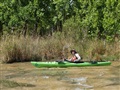
The river banks are lush and green, covered with oak, pecan, and sycamore trees. It looks more like East Texas than at the edge of encroaching Chihuahuan desert.
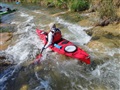
No Internet-accessible gage exists, but there is a gage and I believe its level was 2.5 feet. The river is spring fed and this is a fairly typical level to my knowledge. Although it is runnable, it certainly required a lot of dragging and there were more whitewater ripples and rapids than I had realized. There’s also river cane to make navigation more fun and challenging. Here are some photos of typical river views in the first 6 mile stretch:
|
|
|
|

|
|
|
We loved the beautiful
clear water
|
|
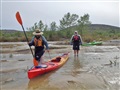
Walking, walking, walking
our boats downstream |

|
|

|
|

|
| Long deep pools occurred frequently – until the next rapid/dam is encountered. |
|
Many stretches like this reminded me of the “flutes” section of the Pecos River.
|
|
Campsite #1 is on an island in the river. It was nicely wooded and shaded.
|
Here are photos of the next day’s segment of river:

|
|

|
|

|
|
 |
| |
|
|
|
Note the private residence
tucked in among the trees.
|
|
|
Just above the San Pedro campsite is a string of springs feeding into the river. I carried all my water (a gallon a day). My kayaking comrades, more space conscious, refilled their water supplies here.
Left is the access to the San Pedro Point campground.
Day 3 include the mandatory portage of Dolan Falls. We approached from river right, got out of our boats there then shuttled them across to river left where we pulled them out and slid them down a rockslide to the eddy below the falls. We did not consider running the falls an option – the water boiling up from the undercut rock directly below the falls made it a no-other-option choice for us.
Staging our boats above the falls for portaging. We shuttled the boats to the other side of the river to haul them up and over the rock ledge, then down the chute to eddy below.

|
|

|
|

|
|
|
Dolan Falls from the
bottom looking up.
|
|
Staging our boats
above the falls
for portaging.
|
 |
|

|
| |
|
The second drop of
Three Tier Rapid.
|
The weather was gorgeous. Lovely day to take your boat for a walk.
Camp #3 was at a big rock outcropping. Tents are pitched on solid rock, no way to get a tent stake in here. We were very thankful that a group of vacationing Midland firemen shared the rock with us.

|
|

|
|

|
|
 |
| Gorgeous weather |
|
Camp #3 |
|
|
|
Yes, indeed the water
was the color you
see here in the photo.
Beautiful.
|
Panoramic view of the river near the takeout; and the river directly opposite the Devil’s Back takeout is below. Thank goodness for Amistad Expeditions’ 4 wheel drive vehicle and sturdy trailer. It was a very long, slow, and treacherous drive to the gated access to this part of the Devils River State Natural Area.


Above is my personal boat and the gear the I carried in it for the trip.
Trip submitted by Natalie Wiest, your happy camper and weary paddler:

Natalie Wiest
Photo album by Wendel Bordelon, here.
Trip member Al Stern has posted his photos and videos to Flickr, here. The stills and videos give you a good idea of how rocky the river is as we thumped on downstream.