| |

|
| |
Location map |
Brazos Bend State Park lies southwest of Houston, and is a huge 5,000 acres in size, with 3 miles of Brazos River frontage. It is great for hiking, bicycling, and seeing giant oak trees, alligators and birds.
Web site: Brazos Bend State Park
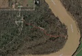
Aerial view: Google Maps
I've been doing some hiking recently in Brazos Bend State Park, and one of the features they show on their maps is a canoe launch site, although they make no mention of it on their web site as part of their facilities. That's odd, and it make you wonder why. So, while I was out hiking, I decided to make a point to go visit this canoe launch and check it out for possible future canoe trips. Here are the findings of my reconnoiter.
The canoe launch is called "Yellowstone Landing", after the 1800's steamship named Yellowstone, which traveled up and down the Brazos delivering goods inland and picking up cotton bales from plantations to take back to the port of Galveston for overseas destinations. In 1845, cotton brokers owned part of what is now Brazos Bend, and it is thought therefore that the Yellowstone would have made stops here.
The canoe launch is in the far north-east corner of the park (see map below). It is not accessible for canoes from the regular roads within the park. It's a 3-mile hike from nearest public parking area to Yellowstone Landing. And I don't know anyone who would be willing to portage 3-miles to get to a river.
So, how does one get there? I talked with a park ranger, and here's the procedure. You first go to the park Headquarters, where you get a permit for entry into the equestrian area which is the trail-head for the trail to the canoe launch. Ask for the combination code to the lock on the gate. Next, exit the park back onto FM 762, drive 2.5 miles north to Sawmill Rd and turn right/east (see the map below). Sawmill Road is paved for about the first mile or two, then turns into dirt and gravel for the last 4 or 5 miles. Top speed on the gravel portion is about 35 mph or your vehicle may start fish-tailing on the loose rock. Drive 6 miles east on Sawmill, to the park equestrian entrance gate. Unlock the gate with the combination code you got at HQ, enter the park, close and lock the gate behind you - standard country gate protocol so that livestock doesn't escape. Park near the trail-head on the left on a gravel surface, not on grass, and unload your canoe. There is a primitive bathroom facility here. Finally, it is a 3/10-mile portage through the woods to the river, down the gently sloped riverbank to the sand bar, and you're there. Easy peasy!
Now, 3/10 of a mile is not a small portage. That's 1,500 feet, or 500-yards. If you have a wheeled dolly for moving your canoe, bring it. Or take a tandem canoe and team up with a large buddy so two of you can carry it together. It still won't be easy.

|
|
 |
| Park map excerpt |
|
Road map |
 |
|
 |
|
 |
| Sawmill Rd. |
|
Entrance signs |
|
Entrance gate |
| |
|
|
|
|
 |
|
 |
|
 |
| Gate signs |
|
Gate locks |
|
Warning |
Brazos Bend Paddling Handout
During my talk with a ranger in the headquarters, he said they don't encourage usage of this launch site, as it is "too dangerous" due to the steep bank. He used that phrase several times. I've done a lot of canoeing on the Brazos, and this bank is one of the least high and steep that I've seen. It's only about 25 feet high and a 30-degree slope. It's on the inside of a bend in the river, which means it has a nice wide, flat sand bar at the bottom. The outside of river bends is where the erosion and steep banks are. There is some mention in internet stories of a rope that used to be present to help you rappel down the bank, so perhaps at one time it was indeed steeper. But no more. I didn't see any rope, and none is needed. Hurricane Harvey flooding must have re-sculpted this riverbank into a more gentle slope in our favor. The ranger who called it too steep and dangerous, apparently has not visited it recently.
 |
|
 |
|
 |
|
 |
| Portage trail aerial |
|
Portage trail |
|
"Too dangerous"? |
|
Needs a canoe! |
It is also worth noting that although they have a launch site in the far north corner of the park, there is no take-out on the south end. So you can't shuttle within the park and have a short 3-mile float down to the other end. There is no park road even close to the river on the south end. So if you're traveling downstream, your take-out will have to be somewhere else further south outside the park.
My conclusion is that this canoe launch is "for show" only. It's popular for parks and counties to advertise canoe launches, but they often do nothing to actually make any improvements to facilitate canoe launching. Politicians like to open them - they get their name and picture in the paper, but then nothing is actually done other than to put up a sign. This site, in my opinion, is another one of those kind of canoe launches. It's on the park map, but actually using it would be very difficult. And I wonder if anyone has ever actually bothered before...
Addendum:
The following input on this canoe launch is from HCC member David Jacobs.
If anyone is planning to use that as a put-in/take-out, I recommend they contact the Park Headquarters a day ahead, to make sure someone will be there to give them the combination at the time they plan to arrive at the Headquarters.
I went there one day, around noon to find out about it, and there was a sign on the door of the little house at the entrance, where you pay, that the ranger was involved in some other program, from about 11 am to 2 pm.
I didn’t want to wait around for two hours, so I left.
I have paddled up to there and back, from the FM 1462 bridge downstream. I used the beach at the canoe launch as a resting/ lunch spot. I think it was about five miles one way, and about ten miles round trip.
With the right river conditions, and an adventurous spirit, it might also be possible to put in upstream, at the end of the short, bike trail #2, off of the Sienna (Brazos River) Park, at “Camp Sienna”:
I’m guessing it would be about a ten mile trip from Brazos Access Trail 2, down to Yellowstone Landing.
Regards,
David Jacobs