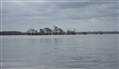
Lake Charlotte is east of Houston, Texas, along Interstate Highway 10, northeast of the Trinity River bridge. The lake is about 1.5 miles in diameter, and has a narrow pass through the woods connecting it to Miller Lake, Mud Lake and the Trinity River.
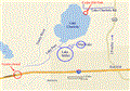 First up for this report, is a map of the area (right), showing the general layout and driving directions. Originally I planned on a canoe put-in under the I-10 bridge at the Trinity River, then paddling north to Lake Pass, and following that north to Miller Lake and Lake Charlotte. However, the bridge access is closed off on both sides of I-10 due to construction of a second, parallel, bridge span. So instead, I drove north on Route 563 to Cedar Hill Park, and put-in on the shoreline at the northeast corner of Lake Charlotte. Then we paddled southwest to Lake Pass and Lake Miller.
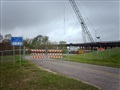 The Trinity River access at the I-10 bridge is closed on both sides (left).
Directions to Cedar Hill Park:
From Houston, drive east on I-10 to exit #810. Turn north on Route 563 and drive for 2.9 miles to Lake Charlotte Rd. There is a road sign on the left, but it’s hard to see because of the orientation of the sign. The landmark to look for is a sign for a Xmas tree farm. Turn left and go 1.1 miles west on Lake Charlotte Rd. Cedar Hill Park does not have a sign at the road. So how do you know when you’re there? Good question. If you get to the 90-degree right bend in the road, you’ve gone too far. The other driveways along the road have mailboxes on them, as they are residences. The Cedar Hill Park dirt entrance road does not have a mailbox, and it’s across the street from a small cemetery. Once you enter that dirt park road and curve around a corner, then you finally see a park sign. Good sign location, eh?
Cedar Hill Park has a restroom in the front section, and if you continue down the road you come to a loop by the lake shore. There is a boat ramp on the loop at a small shell and dirt beach. Just lift up the end of the steel cable blocking off the top of the ramp and lay it on the ground, then drive across it. But if you don’t have much to unload, the distance is very short from the parking, and you can just carry gear from the parking loop. There are also picnic tables by the loop road, as well as a foot path running south along the east shoreline to a public pier.
Two alternate access sites were in consideration back along Interstate 10.
1) On the southwest bank of the Trinity River at I-10 is a “wildlife trace” with dirt roads on top of levees. One of these goes right up to the river, and you could put-in there. But this starts you about a half-mile downstream from I-10.
2) Likewise, on the southeast bank of the Trinity River at I-10 is a public park, with a real boat ramp, at the location of a dam. This would put you about one mile downstream from I-10.
I made this trip with my girlfriend, Kay, and her 85-lb. golden retriever. This dog is very well trained, but not experienced in a canoe. We checked his behavior out in a canoe on a small pond previously, to make sure he would behave, before we got to deep, open water.
 The happy trio at the Cedar Hill Park put-in site, about to hit the river (right). My canoe is an Old Towne Discovery 15'8". The dog did not create a problem by being rambunctious in the canoe, although I did worry about it. He also had his own little doggy life vest just in case he jumped in.
 The water level at the Lake Charlotte gauge this day was at about 8.5 feet. The normal water level seems to run about 7.0 feet. You can view this gauge online at: http://waterdata.usgs.gov/nwis/uv?08067118
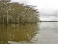 This is the typical cypress swamp that rings the shoreline of the lakes: Just for fun, zip around amidst the trees for a while.
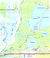 This next map (left) is cobbled together with screen image prints from Topozone on the internet. It’s crude, but it shows the necessary detail. The dotted red line is the course that we paddled. You can view various maps of this area with Topozone, here: http://www.topozone.com/map.asp?
lat=29.85656&lon=94.7321&size=m&u=4&datum=nad27&layer=DRG

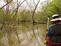
Kay and Truman in the front of the boat (right):
We paddled southwest across Lake Charlotte, found the Lake Pass "channel", and weaved through the dense trees and brush to Miller Lake.
I was surprised at the difficulty of finding the entrances to Lake Pass and Lake Miller. All those trees along the shoreline blend in together from a distance and look the same – there is no obvious gap. At least it wasn't obvious to me. I had to study the map carefully, then paddle right up to where I thought it should be, locate the tiny opening, and then wonder if that narrow weaving gap in the trees is really the official Lake Pass.
Lake Pass was congested with trees, floating logs and overhanging tree limbs (with spiders!), and was good for low-speed maneuvering and spider squashing exercise.
Here are some GPS coordinates I captured of key intersections, which can be used to help find these points amidst the clutter of flora. All of these coordinates are UTM format using datum NAD-27.
Cedar Hill Park beach:
15R 03.33.945 E, 33.06.179 N
Lake Charlotte / Lake Pass intersection:
15R 03.32.645 E, 33.03.985 N
Lake Pass cut to Miller Lake:
15R 03.32.224 E, 33.03.593 N
Miller Lake exit back to Lake Pass:
15R 03.32.255 E, 33.03.475 N
 This photo, left, illustrates the difficulty of finding the pass. The shore looks like a solid line of trees and brush. But this is the actual location of the pass from Miller Lake back into Lake Pass, and you must find it to get off the lake and return to your launch site. So after entering Miller Lake, turn around and study where you are, so that you’ll know how to get back to it. The narrow pass is hidden in those trees!
 This is a typical view of Lake Pass, right, which one local fellow called Two Mile Pass: Notice that it’s narrow, and weaves around downed trees, floating logs, and overhanging branches. At this water level, we never touched bottom, not even with dipping paddles. As congested as this jungle appears, however, there was evidence that someone has been in here with a chainsaw to remove critical obstacles. Whoever that mystery trail-maintenance person is, deserves our thanks. Without that, this pass would be impassable.
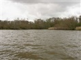
 I was expecting high ground somewhere along the shoreline for a picnic lunch, but we found none - everything was just swampy water at the edges of the lakes. So we tied-up to a cypress tree, snacked in the boat, and saved the lunch for later when we returned to the park. The water level gauge for Lake Charlotte was at about 8.5 feet. The normal level seems to be about 7 feet. Even Bird Island was not an island - it's underwater - there was just a cluster of trees sticking out of the water where Bird Island should be (left).
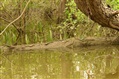 As for other boaters, we encountered only one other canoeist, one kayaker, and a small motorboat in the distance. Other than that, we had the lake all to ourselves for half a day. It's quite a pretty place. There were not a whole lot of birds, but the spectacular ones were the giant white egrets (?) deep inside the trees, which stood out in stark contrast from the normal greens and browns. There were also one pileated woodpecker, numerous grayish-blue herons, and ducks. The wildlife highlight, though, was spying a baby gator lying atop a log (right). Fortunately, we didn’t meet mama.
 At the end of the trip back at Cedar Hill Park, Truman was exhausted!