The Trinity River is east of Houston, Texas, along Interstate Highway 10, about half-way between Houston and Beaumont, at the small town of Wallisville. Lake Miller is an isolated lake about one mile in diameter, lying just northeast of I-10, off of the Trinity River. You can Lake Miller as you go over the Interstate-10 Trinity River bridge if you look to the northeast at the top. Lake Miller is reachable only through a narrow channel in the woods called Lake Pass, which runs between the Trinity River and Lake Charlotte.
Access to the Trinity River under I-10 is closed-off with a fence at this time, due to the construction of a new parallel bridge span.

First up for this report, are two maps of the area, and the water level report. On the west side of the Trinity River is a “wildlife trace”, with a dirt road that approaches the river at several points for boardwalk overlooks, which could be used as a put-in site. And on the east side is the Trinity River Island Recreation Area, which consists of a boat ramp, parking, and picnic areas. See the map, below. Both are free of charge. The Recreation Area has a bathroom. The dotted red line indicates my paddling path up the Trinity River.
(Click images to enlarge.)
For this trip, I chose to try the public boat ramp on the east side of the Trinity River, as indicated by the sign at left.
This is an island park with the Trinity River splitting around both sides of it. The east branch of the river has a dam, and the west branch contains locks. The dam and locks are apparently rarely employed, so most of the time river navigation is unfettered. The dam, at right.
This next map (left) is patched together with screen image prints from Topozone on the internet. It’s crude, but it shows the necessary detail. The dotted red line is the course that I paddled from the Trinity River, under Interstate-10, up Lake Pass, and into Lake Miller.
The water level at the Lake Charlotte gauge (right) this day was at about 8.5 feet. At that level, the ground alongside Lake Pass was about one foot above water, so the channel was clearly defined, and there was no confusion from having water everywhere amongst the trees, with no shoreline banks visible.
I pulled my truck up to the boat ramp area to prepare for the canoe trip. I didn’t want to clog up the concrete boat ramp, which is used by the motorboat folks, so I plunked into the water alongside the parking area. There are rocks there for erosion control, so watch your footing, but that keeps you out of the mud:

The first thing you see as you push into the water and head upstream to the north, are the locks (right), used to move boats between different water levels when the dam is closed. And to keep saltwater from intruding upstream during hurricane surges. Alongside the curb bumpers is a hanging chain with a sign that reads: “Pull chain to use locks”. I was really, really, tempted to pull that chain and see what the Lock Tender would do with my mighty 16-foot canoe. But with my luck, he would have had no sense of humor, and he would have trapped me inside the lock for hours… As it is, you just paddle right on through unimpeded, and admire the massive engineering used to move large gates.

This is typical scenery along the Trinity River here (left). There is no development, and swampland on both sides, so the banks are lined with trees and it is relatively unspoiled.
I started out at 8:30 on Sunday morning, and there was little motorized traffic on the river. I encountered only three boats on the paddle up to Lake Pass. The river is several hundred yards wide at a minimum, and I hugged the shoreline to stay away from high-speed boats in the middle. I cut across the middle only to shorten corners where the river curves, and when I couldn’t hear any motorboats coming.
On the map, the road to Trinity River Island is 1.7 miles. So I figure with the curves in the river, the distance to Lake Pass was about 2.5 miles. It took me several hours to cover this going upstream, and it was a long, somewhat boring, stretch. If I had to do it again, I would shorten the Trinity River distance by putting-in along the Wildlife Trace on the west bank of the Trinity, to allow more time on Lake Miller, instead of spending so much time slogging along up the Trinity.

Here’s a common site along the Trinity River: petroleum pipeline crossing signs (right). In a few cases, the shoreline is cleared of brush to make the signs obvious, like the one below, but in most instances the signs are at least partially obscured by foliage. So, no dropping anchor or dredging from your canoes – you have been warned! There's a whole lot of oil headed to and from Houston-area refineries.
I don’t know what kind of tree this was, but the purple berries enticed me to stop and get a photo (left).
A dead catfish (right). My paddle blade is 8” wide, so that would make this catfish about 48” long! He was a big one.

The I-10 bridge (left). By gosh, this location was noisy. The trucks make a horrendous racket thu-thumping across the pavement and steel girders on high-pressure tires. I couldn’t wait to get beyond it to peace and quiet again. But while the noise quickly diminishes, the truth is, even in Lake Miller you can almost always hear highway traffic along I-10 in the distance.
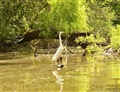 Just north of I-10, the first channel on the right is Lake Pass. Guarding the entrance was this regal-looking egret (right). I’ve discovered that the noise of a paddle in water frightens birds off early. So my photo technique now is to paddle-up some speed and momentum from a distance, aim carefully, and then glide silently towards your feathered foto subject. That way the birds will sit still longer, allowing you to get closer, before they become wary of your presence and fly off.
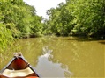 A typical scene from inside Lake Pass (left). This is the wide part, believe it or not. It grows narrower the further upstream you go, and you end up winding your way between logs and trees. I even encountered a small motorboat way up there, tied up to a tree, manned by two fishermen. I was quite surprised to find them that far up that narrow winding channel. With multiple lines in the water, they had the monopoly on any fish that would dare to swim through.
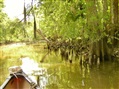 Lake Pass scenery, with cypress stubs and overhanging Spanish moss (right). There were also a few overhanging large wasp nests - don’t disturb those. And if you brush through tree limbs, your boat will fill up with gangly-legged spiders. Feel free to scream like a girl.
As you go upstream through Lake Pass to Lake Miller, there are four channels branching off to the right. The first is very obvious and goes into a triangular pond that looks man-made. The next two are narrow ditches that veer off to the right. I tried paddling up those ditches looking for a shortcut to the south end of Lake Miller, but they are too narrow and clogged with logs and trees. The fourth channel is the one you want to get to Lake Miller. It’s not real obvious – just water flowing through trees, and it’s very narrow and winding. However, it’s also very short – maybe 100 yards, and then you pop out into the open water of Lake Miller.
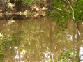
 Typical scenery in Lake Miller (left).
Remember where you came out into Lake Miller, because it’s hard to find on your way back. It’s in the northwest corner. A good landmark is a lone short stubby cypress tree just outside the pass, which looks like a Japanese bonsai tree.
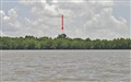 Lake Miller is about a mile in diameter. My goal this trip was to try and find the plaque honoring Mr. Miller, for whom the lake is named. The trick for that is to aim for the tallest tree you can see sticking out above all the others, on the south shoreline, just a bit west (left) of center (photo at right).
Arriving at the south shoreline, you’ll have to find a path through all the cypress knees, to get to land. The cypress stumps are tightly packed and randomly arranged, so finding a straight shot through them isn’t easy. While most of the lake is surrounded by swamp, the south shoreline has some “high” ground, nice grass and plenty of shade. It’s a great place to have a picnic lunch.
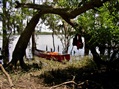 Beached on the south shore of Lake Miller (left).
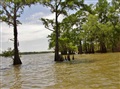
 There are plenty of beasties present here. This land has about five parallel pipelines crossing over it, running east-west with the shoreline. The ground over those buried pipelines is kept cleared of trees, which makes for open grassy strips, and grazing land for Texas longhorn cattle, which cut an imposing and intimidating figure:
 Along with the big pointy-horned beasts, are a few ponds, complete with gators. This photo isn’t very good, but veteran gator-watchers will recognize that sun-dappled silhouette in the water:
And if that’s not enough beasties for you, there was also a family of wild pigs in the woods, which were too quick to vanish for me to capture their family photo.
Birds seen, in descending order of frequency, were: egrets, herons, a few ducks and one ibis. Fish spotted were: mullet, gar and catfish.
The mullet are numerous in Lake Miller, and seem to take pleasure in repeatedly jumping out the water. When you spot one jumping, it’s a good bet that he’ll continue to do so three or four times in a straight line. So I was amused when I saw a mullet take his first jump just off my left bow and headed towards me – I waited to see what would happen next. Sure enough, his second jump took him right over the bow of my boat and into the water on the other side. I could swear he winked his little black eye at me as he went soaring by.
Oh, and alligators, I can’t forget those. On the Trinity River I think I saw only two. But once up into Lake Pass and Lake Miller, I spotted about eight more. They mostly are lying under the surface with only the top of their head showing, and they dive under and disappear when you draw close. That actually makes me a bit nervous not knowing where they are – I would rather keep them in sight so I can avoid them. But they do a good job of getting out of your way on their own. The cutest one was about a two-footer, sunning himself on top of a log, just above the water. None were aggressive in any way, as usual. They really aren’t much to worry about - just don’t go dangling a stringer of fish over the side of your canoe.
 Not all of the beasties live happily ever after (right):
I trudged around for quite a ways in three directions trying to find the Miller plaque, to no avail. I kept looking for something obvious, something on clear, high ground. But that wasn’t working. I remembered reading that it was near those tall trees. The problem is that once you beach on the shoreline, you can’t see the tall trees anymore – they all blend in together in the forest, and there is no way to see which ones stick up higher than the others. There are a series of parallel clearings where the pipelines run through the area, but even standing on those clearings, those trees were not identifiable.
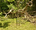
So I finally headed back to the canoe and started over again, just using dead reckoning, with the angle I remembered towards the tall trees when I first beached my canoe. And lo and behold, in less than 100 yards, I was there! While the treetops may not be obvious, a related clue is the massive tree trunks for those large trees. So look for tree trunks that are larger than all the others. There are actually two large trees there, and one is a live oak with its characteristic multiple trunks radiating upward and outward in all directions. The location is not that far from shore, and inside the shoreline band of trees before you get to the first pipeline clearing. So, if you reach a pipeline clearing, you’ve penetrated too far through the woods.
And if it weren’t for these steel stakes driven into the ground around the plaque, below, it would be even more difficult to find the site. These stakes stick out like a sore thumb in the otherwise natural surroundings, so that’s a good clue for you. And finally, the plaque itself, inside the protective ring of stakes.

The grass had grown over top of the plaque around the edges, so I did some grooming to clean it up and clear it. And since this was Memorial Day weekend, I instantly regretted not having brought along a flag to place beside this soldier’s plaque. So if one of you reading this ever plans on going out that way, please take Mr. Miller a small flag and plant it alongside his marker. He fought in a pivotal battle for America’s freedom and independence, 195 years ago.
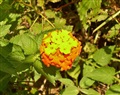
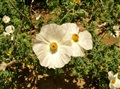
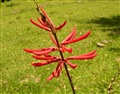
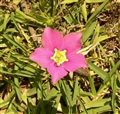
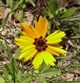
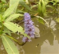
There were also numerous beautiful flowers along this stretch of land, a sampling of which is shown below:


After spending about an hour ashore, locating the Miller plaque, and eating a leisurely picnic lunch, I pushed off into the water again. From here, I headed from the south end to the northeast corner of Lake Miller, looking for the narrow pass to Mud Lake. Despite going back and forth several times, I could find no obvious opening. That will have to wait for yet another day. Perhaps at higher water levels, you can just paddle amidst the big cypress trees to work your way through the swamp to Mud Lake.
My exploration done, I headed back through Lake Pass, down into the Trinity River, and back to the island boat ramp location. This time, mid-afternoon, there were dozens of boats zipping back and forth on the Trinity. About 15% of them were polite enough to throttle back and reduce their wake when they spied my little canoe along the shoreline. But the large majority of them flew by at high speed without a second thought to me. Despite that, I did not feel like their wakes presented any danger of swamping or overturning my boat – they weren’t that big. Only a couple of times did I feel it might be wise to turn my bow into the waves.
Here are some GPS coordinates I captured of key intersections, which can be used to help find these points amidst the clutter of flora. All of these coordinates are UTM format using datum NAD-27:
Lake Pass cutover to Miller Lake:
15R 03.32.224 E
UTM 33.03.593 N
Miller Lake exit back to Lake Pass:
15R 03.32.255 E
UTM 33.03.475 N
Miller plaque:
15R 03.32.748 E
UTM 33.02.534 N
It was a pleasant and interesting day on the water.