San Bernard River
Jan 17, 2014
by Dave Kitson
Natalie Wiest had sent me an e-mail a few weeks ago about a HASK trip to the San Bernard River. I was unable to make that trip but wanted to check it out for a possible Club outing, so Joe Coker and I decided to explore it on Friday the 17th. To my knowledge the Club has not paddled the San Bernard, but it is closer to town than Lake Charlotte and, if the HASK information proved correct, is essentially a cypress swamp type of environment so it looked like a great place to go. Here are the directions:
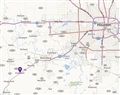
South on Hwy 59
Take the exit for FM 2919, the second marked as Kendleton.
Turn left at intersection (Lum Rd/Main St),
Cross under highway 59 and move to the right lane in order to take the 1st right onto Charlie Roberts Ln/Roberts Ln.
Follow road past a left turn and continue to the park and then continue straight
Boat Ramp is at the west end of the park (Don’t know if this is Bates Allen Park or Bernard Park but how many parks could there be in Kendleton), down a short well graded gravel drive.
 |
|
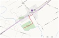 |
The put-in is an excellent boat ramp and there is plenty of parking. There are also a couple of picnic tables so lunch in the park is a possibility.
Joe and I headed upstream on a relatively wide river with little current. Before we reached Hwy 59, however, we began to encounter a fairly stiff current (I would guess at least 2 to 3 MPH) which would be with us for the whole day off and on. The banks are indeed lined with cypress trees many of which are absolutely HUGE. One of the trees consisted of 7 ~ 2’ diameter trunks in a row more or less; it was probably 12’ wide. There are many cypress trees larger than what is found in the Lake Charlotte area.
We paddled under Hwy 59 and, before long, had gone far enough that there was no sound which left us in complete peace and quiet. There is very little evidence of civilization on this river except for pretty much continuous barbed wire fence so the feeling is of being out in the middle of nowhere. There were quite a few fallen trees so that we spent a fair amount of time trying to get around them and I would guess that at lower water levels it would not be possible to go as far as we did. At higher water levels or faster currents there were a couple of spots that might be a little dangerous or tough to get around. Most of the streams we paddle on are small local streams which peter out within a few miles of the put-in, however, the San Bernard is a river, so although, it gets wider and narrower here and there the flow is consistent and it never disappeared.
There were quite a few birds around; hawks of indeterminate pedigree, a couple of barred owls, woodpeckers and super friendly kinglets among others. I was able to paddle over to one kinglet within 5’ and check it out. Then it flew closer, less than 3’, I could have petted it easily.
The trip ended up at 10.1 miles and 5.7 hours and there is still a downstream trip out there to be explored.
Joe has loaded photos to the website so check them out here.
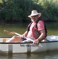 |
| The author, Dave Kitson |