The Charlotte Sand Hills Loop
Dec. 4th, 2013
by Joe Coker
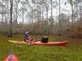
Wednesday 12/4 was a nice balmy day....partly sunny, high in the mid 70’s, light winds....my kind of Houston winter. Dave and I decided to take advantage before the cold wave hit and do a scouting paddle out on Lake Charlotte. High water at almost 11 feet offered good options to go deep into the cypress forest. We had wanted to try a repeat visit to the mysterious Sand Hills between Wes Cove and the Trinity and especially wanted to attempt the complete loop by returning to Cedar Hill via the Trinity and Mac Bayou. So, that became the main objective for the day, and happily, we were totally successful!
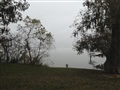
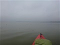
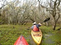
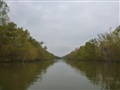
Charlotte was still completely shrouded in fog when we pulled into Cedar Hill around mid-morning. It was eerily quiet and the lake was like glass in the dead air. By the time we put in at 11:00, the fog had lifted a bit and you could finally see the far shore, but it was still invitingly spooky.
Our route was to go straight across to Sand Island and then south hugging the west side through the trees all the way down to about the middle of Wes Cove. That point would give us the shortest cut across to the Dunes and the easiest portage beyond to the Trinity (total lake to river about 0.20 miles).
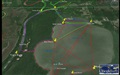
The following pics show the foggy conditions and a map of the complete loop (purple track in photo 2, below), approximately 5 miles long.
 |
|
 |
|
 |
|
 |
| Foggy Charlotte |
|
Joe's route map
Sand hills loop |
|
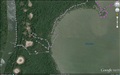
Dave's GPS
Sand hills |
|
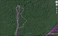
Dave's GPS
Secret cut |
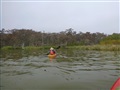
Reaching Sand Island, we remarked at how thick and high the foliage was getting. Less than 10 years ago, it was just a sandbar where you could easily get out and walk around. Perhaps by next year, the birds will start nesting there. It was also interesting to note how much the saw grass had filled in along the back side which we had long ago dubbed Gator Alley....for good reason. Last winter, the passage was 10 to 15 feet wide and easily negotiable....when the gators were sleeping. Now it’s nearly all closed in. We speculated that it won’t be long before a little more growth and inevitable silting-in will cause Sand Island to no longer be an island.
 |
|
 |
| Flat water |
|
Sand Island/
Gator Alley |
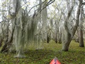
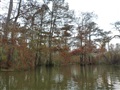
The trip down the west coast is beautiful, no matter what time of year. With the high water, we were able to paddle in much deeper than usual making it even more interesting. The lingering fog in the trees added a special touch, and the fall colors were spectacular.
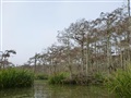 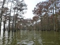 |
| West coast scenery |
Gliding into Wes Cove, we began looking for a viable cut-in to the Dunes. At first, the dense undergrowth looked absolutely impenetrable, and we hadn’t thought to bring our usual bushwhacking gear. However, upon venturing further in, we found it much less difficult than expected to zig-zag our way through. Actually, the only real impediments were some thick patches of salvinia. Sad to see how packed-in the dreaded weed was becoming. Couldn’t help thinking that at the current fast rate of infestation, all routes though there might be totally impassable by next year.
  |
| Cut to the sand hills |
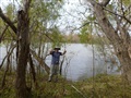
As we approached our destination, the water got remarkably clear, and it wasn’t long before the sand hills loomed dead ahead. The cut-through had taken us less than half an hour. Our contact point was approximately in the middle of the sand hill array, the most visible portion of which stretches roughly north/south for about half a mile paralleling the Trinity.
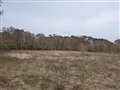
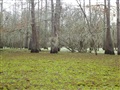
Where we were, the land rose perhaps 5 to 10 feet above the water level, but the features were relatively flat except for a mysterious, crater-like depression approximately 40 yards in diameter, descending to a depth of 3 or 4 feet. Sizable random deposits of clam shells indicated the presence of early inhabitants. In fact, a local fisherman we encountered back at Cedar Hill mentioned that bones and relics had been found out there years ago. Hundreds of animal tracks were also a testament to abundant wildlife in the area....we identified deer, hog, raccoon, bobcat, snake and Texas water buffalo (cow).
 |
|
 |
|
 |
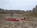
| Trinity success |
|
Mysterious crater |
|
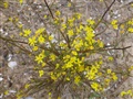
Flowers & shells |
How the sand hills were formed and the variety of the features is an intriguing mystery. It hadn’t occurred to me until Dave mentioned it, but the entire piece of land we were on is actually a huge island bounded by Lake Pass, the Trinity on the west, the Sulfur Cut and Mac Bayou on the north and Charlotte on the east. One might theorize that it was originally just a big sandbar which eventually grew to the point of closing off the oxbow hence forming the lake. That could explain the existence of all the sand there which actually extends well to the north of the most prominent section we were exploring. Google shows traces as far as 1.3 miles up near the Sulfur Cut. However, it still leaves one wondering about the present-day variety of the features. A case in point is the strange conical dune to the south which beckoned to us and was within relatively easy hiking/paddling distance. So much more to explore, but we decided to leave it for next time. After eating lunch and wandering around our immediate area for a while, we were anxious to continue the Loop.
The portage over to the Trinity proved to be fairly easy.....about 120 yards, but open terrain except for the tree line next to the river. Even the carry through there was easy given the many animal paths leading to the water. Once there, we found the put-in to be easy as well.
  |
| The portage |
After taking numerous celebrity photos commemorating the Crossing, we finally hit the water again and began the homeward leg. An opposing current of about 2.5 mph on the Trinity made for slow going, but with the welcome assist of a light south breeze, we did the 1.4 miles to the Sulfur Cut in about 40 minutes. The still waters there were a welcome relief as we turned the corner heading for Mac Bayou.
 |
|
 |
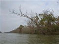
| Trinity north |
|
Sulfur cut |
With some time to spare, we decided to turn north on the Bayou and take further advantage of the high water to see how far into Secret Cut we could get. The familiar group of “Knee People” guarding the entrance was completely submerged, but the main body of the cut was as beautiful and peaceful as ever with the subtle hues of winter providing an interesting contrast to the greenery of spring/summer we’re more accustomed to seeing. As we paddled deeper and deeper, there were huge expanses of duckweed and salvinia as far as the eye could see. Often clear lines of demarcation made it appear as if the two were competing for space. Sadly, we knew who the victor would eventually be. With cloudy skies obscuring the sun, it was easy to become disoriented back there as we zig zagged around taking in all the great sites. Thank goodness for GPS. Paddling onward, we could see clear passage for hundreds of yards ahead and could have gone in much further, but light was fading, so it was time to head for home.
 |
|
 |
|
 |
| Groovin' Dave |
|
Duckweed/salvinia |
|
Bayou color |
Back on the main channel, we paddled briefly toward Mac Lake and before finally turning around were treated to wonderful splashes of color in the distance and across the way in the small rookery. A slight favorable current on Mac Bayou aided our progress, and we quickly made the transit to Charlotte. As usual at that time of day, it was a bumpy ride over to Cedar Hill, but not nearly rough enough to dampen our elation. We had made history (for ourselves at least) by successfully completing the Sand Hills Loop and had a great time doing it! Truly, it had been yet another extraordinary Lake Charlotte adventure!
Additional photos from Joe are available on the HCC photo album page, here.
 |
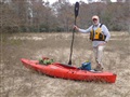
| The author, Joe Coker |