HUGO POINT/SHELL MIDDEN LOOP
Trinidy Bay
April 16, 2022
by Joe Coker
Location: Cove, TX
Conditions: Partly to mostly cloudy. Temp. Mid 80’s. Wind SSE 10-20
Route: Hugo Point/Shell Midden. Out and Back
Distance: 9.8 miles
Time: 6 hrs. 9:30am to 3:30pm
Participants: Natalie Wiest and Joe Coker (Co-leaders), Tom Douglas, Bob Scaldino, Richard Sproll (guest)
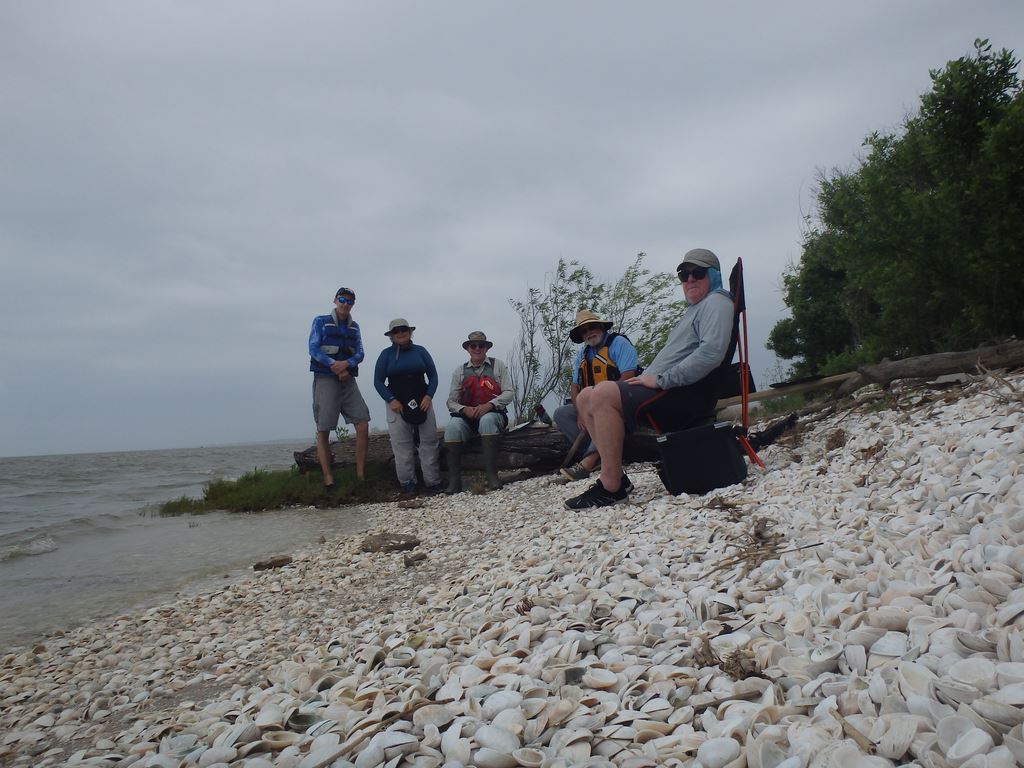
Photo by Natalie Wiest
The Hugo Point/Shell Midden Loop is an old favorite we hadn’t paddled in a long while. Last weekend was high time for a visit!

Map provided by Joe Coker. Credit Google Earth
The area comprises hundreds of acres of marshlands and trails just southeast of Cove, Tx, along the North Trinity Bay. It is bordered on the west by Dutton Lake and Cotton Lake, on the north and east by Old River Lake and Old River, and on the south by Trinity Bay.
The section we usually paddle is the corridor of winding channels south of Hugo Point adjacent to Cotton Lake and Dutton Lake on the west. Our primary destination is typically the iconic Shell Midden at the opening of Cross Bayou on Trinity Bay.
There are dozens of convoluted channels snaking through the marsh and at least 6-8 opening to the bay. The most commonly paddled are Cross Bayou which leads directly to the Midden, and High Tree/Red Bayou that roughly follows the border of Dutton Lake down to the bay. From its mouth over to the Shell Midden is about 1.25 miles east.
The most common loop commences at Hugo Point and goes counter clockwise along the southeast side of Cotton Lake, then down High Tree/Red Bayou, across the bay to the Shell Midden, then up Cross Bayou past the Delhomme Estate and back up to Hugo Point. However, there are numerous variations on that theme and countless other places to explore.
In general, the coastal marsh offers relatively safe and easy paddling. However, there are a number of pertinent factors to keep in mind:
- Perhaps the most important issue governing paddles in this area, given the proximity to the bay, is Wind/Weather. Wind below 10 mph is ideal. Up to 15 is doable. Winds 15-20 and above are unpleasant at best, can be dangerous along the open bay and are not recommended.
- Paddling in the marsh requires competent navigation. Given the vast number and convoluted nature of the channels, accurate maps and a compass are essential. Plan on getting a little lost. If you get very lost, at least cell service seems to be available throughout the area. Beginners beware!
- Tidal flow, particularly in combination with the wind can be another factor to contend with. Old River Lake and the bayou openings to the bay can be especially troublesome. Low tide particularly in conjunction with a north wind will often lower the water level in Cotton Lake resulting in shallows and mud flats in some spots. Fortunately, this doesn’t usually affect navigation on the Midden Loop and indeed adds the benefit of attracting lots of birds!
- There are good bathroom facilities at Hugo Point Park, but nowhere else.
- No concessions in the area, so be sure to bring adequate water and snacks.
- Hugo point offers a good boat ramp. Landing spots in the marsh are few and far between.
- Both canoes and kayaks are suitable. Spray skirts may be necessary out on the bay.
Conditions for our 4/16 paddle were good, albeit a bit breezy. The original plan was to do the regular counter clockwise loop via Red Bayou on the west side and down to the bay, across to the Midden, then up Cross Bayou returning to Hugo Point. However, early-on we realized the winds, SSE in the low to mid-teens, gusting to 20 might be an issue on the 1.25-mile bay crossing. So, we altered the plan and instead took the clockwise route down Cross Bayou. This brought us directly to the Midden (our main goal) and provided the option of returning by the same route or attempting at least a partial traverse on the bay, if it wasn’t too rough.
Pooling our old recollections, maps, compasses, and GPS technology, we managed to conquer the marsh maze without mishap. The water was fairly high, and the channels were clear and generally protected from the worst of the wind. Many flowers were in bloom—spider lilies, huisach trees, sagittaria and thistle. Wildlife sitings were on the low side, but Redwing Blackbirds were abundant along with the usual variety of larger shore birds. A few smallish gators wallowed about here and there. Overall, the wide-open spaces, soft blend of marsh vegetation and casual meandering made for a pleasant, peaceful paddle.
The main event of course was visiting the Shell Midden. It’s one of the biggest, extending perhaps 200 yards down the shore. My first impression was how much more vegetated it was. Most of my previous visits were in the years right after Hurricane Ike, which left the entire area scoured in every direction. Nice to see many flowers, bushes and small trees filling in again along the shore.
After a relaxing lunch on the shell beach and some brief exploring, we huddled to decide on the return route. The wind had dropped a bit but the bay was still bumpy making the thought of paddling the full distance over to Red Bayou unpopular. So, we agreed to try going up Double Bayou, only about 0.45 miles down the way. Years before, it had been blocked with hurricane debris, but surely would be clear by now and definitely worth a shot. Our gamble paid off. We had great conditions all the way up, even a little helping breeze. At a main intersection, we went left to pick up High Tree Bayou, then up to Cotton Lake and the final stretch back to Hugo Point.
We were a tired but happy bunch! It was another great day on the water!
Note: See pics and maps in my album on the Photo page of the HCC website. Photo Album
To see an account written by trip participant Tom Douglas and more photos that he took during the day, be sure to check out his story in the newsletter of the Houston Sierra Club here.
 |
|
The author, Joe Coker |