Scouting Mac Lake and Mac Bayou on Father’s Day
June 15, 2014
by Natalie Wiest
Joe Coker was putting together his Summer Smash trip for the following weekend, and wanted to scout out a route so it took little convincing for Dave Kitson and me to join him, and we even roped in Club newcomer Larry Newbern to come with us.
Knowing the heat was going to be on, we opted for an early start from Cedar Hill Park – meeting at 8:30 in the morning. Only glitch was Joe’s discovering in his haste to pack his gear he’d included two halves of two different paddles that would not mate together, so he ended up single-blading it in his kayak. Made for an interesting paddle for him across Lake Charlotte in a fair amount of wind and chop.
 |
|
 |
|
 |
| Larry Newbern |
|
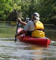
Dave Kitson |
|
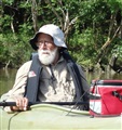
Joe Coker
single-blading |
The Lake Charlotte gage (USGS station 08067118) was reading about 8.25 feet and we had an array of inbound and outbound currents as we paddled, due to varying river flows and the wind but nothing over challenging.
We headed out across the Sulphur Cut on Mac Bayou and began checking out as many side channels as we could float. This area is always beautiful and green this season of the year. Although we saw the start of a salvinia bloom, the passages were all open and easy enough to paddle. We were disappointed to find that the bird rookery that had been home to many birds last year on Mac Bayou was totally abandoned. We saw the old nests, but nary a bird to be seen.
Lizard’s tail (Saururus cernuus) was in bloom many places in the shade, and a few pickerelweeds as well. We also discovered a recently-constructed duck blind on Mac Lake.
Joe and Dave have become expert at more side-trips here than I ever imagined from earlier times I had paddled . Attached photos include the GPS tracks of our paths as created by Dave and superimposed on Google earth maps. It sure is nice to have someone adept with GPS on the trip as we get way back into the woods and the path out is not always as obvious as we thought when we paddled in. At this water level, we were able to paddle the upper end of the lake and bayou to a utility right of way, where the vegetation has become so thick we can go no farther although there might be enough water at this level or higher to push it farther.
This is another of the area trips where getting to dry ground to get out of our boats is impossible. My kayak developed some leaks and I wanted to take one of my own so I got out along the portion of the bayou east of the sulphur cut. Looked really snakey to me so I was looking very carefully where I was walking. Of course, as I got to the relief spot and squatted down, there was a good-sized snake only a few feet from me. Got a good photo and skedaddled out of there.
We paddled about 9 miles and had a great time out in the woods and across the bayous. We returned to the park by 3 p.m. and were soon on our ways home, and looking forward to the next opportunity to paddle this beautiful area.
I have posted more photos at my Flickr account: here
Natalie Wiest
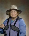 |
| The author, Natalie Wiest |