Buffalo Bayou
August 4th, 2012
by David Jacobs
Thanks to Tracy Caldwell, for volunteering to do the shuttle.
The flow rate at the Piney Point gauge was around 1100 cfs.
It took 2 hours, 43 minutes to go from Highway 6 to Briar Bend Park. This time included a 15 minute stop for a snack.
At Briar Bend Park, the water looked about three feet lower, compared to the 1830 cfs level Dave Caddy and I did the weekend before.
There is a place to pull off of Hwy 6, just North of the bridge, on the North-bound side. The bank and river bed are covered with concrete beside and under the bridge. The concrete bank was too steep, but just downstream was a pathway, with timber steps. About 20 feet down the pathway, it forked right and left. In the left fork, there were five or six dead gar fish. They were about five feet above the water level. I swept them into the water, with my kayak paddle. A few feet past that, the path was wet, muddy and slippery. The fork to the right had a broken slab of concrete, projecting out of the water, and up the bank several feet, at which point the pathway was flat. This made a place to get into the boat, and then slide on the concrete, into the water. Some pedestrians on the hike & bike trail stopped to watch. The water was too shallow to paddle upstream, over the concrete stream bed. I was surprised that there was almost no flow rate here.
I headed downstream at 12:47 PM.
I had to go under many, low, over-hanging tree tops, between there and Memorial Mews. If the water had been three feet higher, I would have been paddling through the branches in those tree tops! One place, I had to take off my Camel Back, hydration backpack, in order to lean back far enough to barely push myself under a limb.
It took 16 minutes to get from Hwy 6 to the stinky water, coming in along Memorial Mews. This is where the main flow was coming from. Downstream from Memorial Mews, a cable across the bayou, which Dave Caddy and I had paddled over the weekend before, was now hanging above the water. I was able to paddle cleanly under it, sitting straight up in my kayak. From Memorial Mews to Briar Bend Park, there were about six places where downed trees crossed the bayou. I was able to get up enough speed to ramp over all of them except one.
Beltway 8 is about the halfway point. I stopped there for 15 minutes, to eat some carbs and raw vegetables. A little way downstream, just upstream before Gessner, a downed tree was lying out of the water too much to ramp over it. Eventually, I avoided a muddy portage, on river right, by pushing on a deeper downed tree, to push myself over the one liyng out of the water.
A nice bonus about paddling on Buffalo Bayou is that the shade protects you from the sun. And sometimes a breeze comes through, which makes it even better. I arrived at the Briar Bend Park take-out at 3:30 PM.
The weekend before, with the flow at 1830 cfs, Dave Caddy and I went from Memorial Mews to Briar Bend Park in two hours, without stopping. From my 2 hr-43 minutes, subtracting 16 minutes for the extra distance from Hwy 6, and another 15 minutes for stopping to eat, the same distance took me 2 hr-12 minutes, at a flow rate of 1100 cfs. Some of the extra 12 minutes was due to having to struggle over the downed trees, all of which had been under water the weekend before, except for the high one, which Dave was able to scoot over, after getting stopped on it.
 |
|
 |
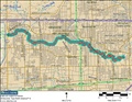
| Map |
|
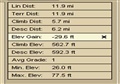
GPS data |
More GPS data:
ñ Start Time: 8/4/2012 12:43:52 PM CDT
ñ Finish Time: 8/4/2012 3:35:06 PM CDT
ñ Distance: 11.89 mi
ñ Average Speed: 4.2 MPH
ñ Average Moving Speed: 5.2 MPH
ñ Average Elevation: 100 feet
ñ Minimum Elevation: 49 feet
ñ Maximum Elevation: 167 feet
ñ Acquisition Street: Del Glen Ln | Blalock Woods St | Holly Terrace Dr (SR 6)
ñ Finish Street: Woodway Dr
ñ Acquisition Coordinate: N29° 46.1611' W95° 38.5694'
ñ Finish Coordinate: N29° 44.7698' W95° 30.4656'
ñ Time from Start to Finish: 2:51:14 (hr:min:sec)
ñ Time Moving: 2:18:25 (hr:min:sec)
ñ Time Stopped: 0:32:49 (hr:min:sec)
ñ 11.89 miles
Link: Buffalo Bayou Paddling Trail
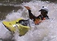 |
| The author, David Jacobs |